

Why the phrase ‘Super El Niño’ makes Australian climate scientists roll their eyes
- Written by Kimberley Reid, Postdoctoral Research Fellow in Atmospheric Sciences, The University of Melbourne
Frightening headlines predicting a Super El Niño or even a Godzilla El Niño amp up anxiety levels for farmers and residents of bushfire-prone regions.
But these phrases are not particularly accurate. The phrase “Super El Niño” makes climate scientists like me roll our eyes.
Why? Let’s find out.
What is El Niño?
The El Niño–Southern Oscillation is a natural and reoccurring climate pattern in the Pacific Ocean which can influence the chance of different weather affecting Australia.
When sea surface temperatures near the Americas are warmer than usual and the trade winds blowing from east to west across the equator weaken, climatologists call this pattern an El Niño.
El Niño events typically ramp up in winter and spring, and decay towards the end of summer and start of autumn.
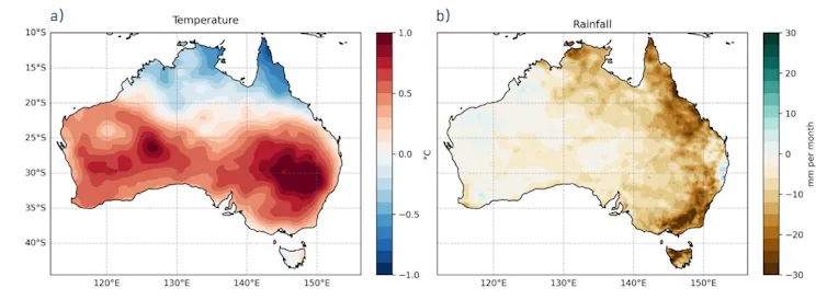
During El Niño, we tend to experience warmer than usual temperatures and reduced winter-spring rainfall in Australia’s east.
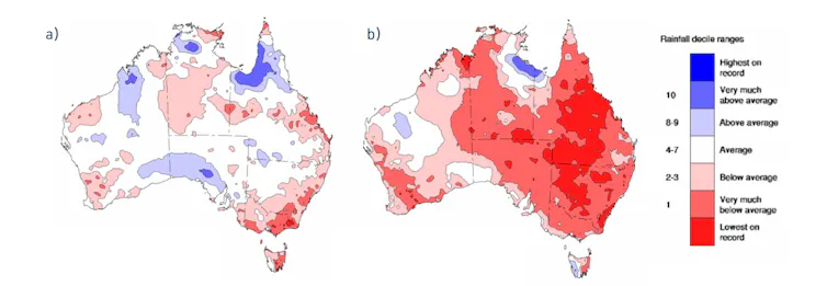
We pay attention to El Niño and its opposite, La Niña, because this climate pattern has the biggest influence on year-to-year rainfall and temperature differences in eastern Australia. Drought is a key concern for farmers and rural residents, and some of the largest droughts of the past 40 years took place during El Niño years.
But problems can arise if we expect El Niño to be the only factor dictating our weather.
Why call an El Niño ‘super’?
One El Niño can be stronger or weaker than others. Scientists monitor El Niño using the Nino3.4 index, a measure of how much warmer (or cooler) than usual the ocean is in a region in the East Pacific. This region is the best at representing changes in the Pacific which can indicate El Niño.
When ocean temperatures are 0.8°C warmer than usual in that region, and the trade winds have sufficiently weakened, the Bureau of Meteorology can declare an El Niño has arrived. (The United States uses 0.5°C as the figure).
A “Super El Niño” is when the region’s ocean temperatures rise 2°C, roughly two standard deviations above normal (about a 2.5% chance of happening). While scientists first coined the term, the evocative phrase has become a favourite of media commentators.
But Australian forecasters don’t use these terms, as it doesn’t matter that much for our weather if the index goes over 2°C. What matters much more is whether an El Niño is present or not.
Why? When we measure the strength of the El Niño, we are really only referring to ocean temperatures in the eastern Pacific. But this figure is not very well correlated with less rain in eastern Australia. It also only captures ocean changes and doesn’t reflect the El Niño atmospheric changes which influence the weather systems that actually bring rain to Australia.
That’s not all. The Niño3.4 Index is just one of many indications of how Australia’s upcoming weather is likely to look. One index can’t tell the whole story. Relying on it is like looking at the BMI of a bodybuilder and declaring them obese.
Readers may wonder how scientists can define El Niño using an ocean temperature threshold when oceans are getting steadily warmer under climate change. Won’t we end up with constant El Niño?
This is a good question. It’s why the Bureau of Meteorology last year introduced a relative Niño index, to give scientists a way to account for warming due to climate change.
Should we believe winter and spring forecasts?
A Southern Hemisphere autumn in the Pacific Ocean is sort of like January in your average Australian office job. As you slowly ease into the work year, you set a bunch of optimistic goals which may or may not eventuate.
Over autumn, the Pacific Ocean is similarly noncommittal. It can indicate future outcomes that don’t always happen.
Meteorologists have a term for this. It’s called the Autumn Predictability Barrier. What it means is that El Niño forecasts are the least reliable during autumn.
So while forecasts of the Pacific Ocean might be pointing towards an El Niño, history warns us to take forecasts made in autumn for later in the year with a big lump of salt.
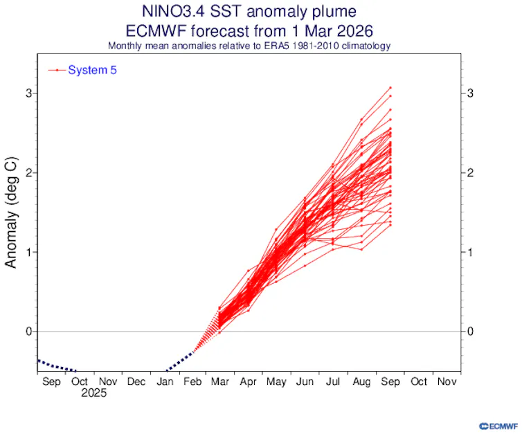
At present, the European, US and Australian model forecasts of Niño3.4 indicate a strong El Niño might develop. But this isn’t conclusive.
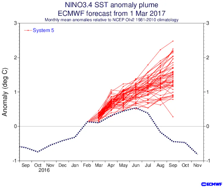
The forecasts made in March 2017 are worth looking at. Here, models confidently predicted a moderate and long-lasting El Niño, similar to forecasts in March 2026. What happened instead was a short-lived, weak El Niño.
How should we think of El Niño forecasts?
As a scientist who has researched seasonal forecasts of Australian rainfall, my advice is to ignore autumn headlines warning of a potentially catastrophic “Super El Niño”.
These get more clicks than more accurate headlines pointing out long-term forecasts at this time of year are uncertain. It’s worth waiting until the end of autumn or early winter before taking El Niño forecasts too seriously.
The current gold standard for Australian seasonal forecasts are the Bureau of Meteorology’s long-range forecasts. But even here, these forecasts become quite uncertain more than a month in the future. It’s important to regularly check for updated forecasts.
Will we get an El Niño this year? The only scientifically accurate answer as of April 9 2026 is “maybe”. It’s way too early to say anything other than that an El Niño is more likely to form this year than a La Niña.
Authors: Kimberley Reid, Postdoctoral Research Fellow in Atmospheric Sciences, The University of Melbourne


