

A man scouring Google Earth found a mysterious scar in the Australian outback – and now scientists know what caused it
- Written by Matej Lipar, Adjunct Research Fellow, School of Earth and Planetary Sciences, Curtin University
Earlier this year, a caver was poring over satellite images of the Nullarbor Plain when he came across something unexpected: an enormous, mysterious scar etched into the barren landscape.
The find intrigued scientists, including my colleagues and I. Upon closer investigation, we realised the scar was created by a ferocious tornado that no-one knew had occurred. We outline the findings in new research published today.
Tornadoes are a known threat in the United States and elsewhere. But they also happen in Australia.
Without the power of technology, this remarkable example of nature’s ferocity would have gone unnoticed. It’s important to study the tornado’s aftermath to help us predict and prepare for the next big twister.
Australia’s tornado history
Tornadoes are violent, spinning columns of air that drop from thunderstorms to the ground, bringing wind speeds often exceeding 200 kilometres an hour. They can cause massive destruction – uprooting trees, tearing apart buildings and throwing debris over large distances.
Tornadoes have been reported on every continent except Antarctica. They most commonly occur in the Great Plains region of the United States, and in the north-east region of India–Bangladesh.
The earliest observed tornado in Australia occurred in 1795 in the suburbs of Sydney. But a tornado was not scientifically confirmed here until the late 1800s.
In recent decades, documented instances in Australia include a 2013 tornado that crossed north-east Victoria and travelled up to the New South Wales border. It brought winds between 250–300 kilometres an hour and damaged Murray River townships.
And in 2016, a severe storm produced at least seven tornadoes in central and eastern parts of South Australia.
It’s important for scientists to accurately predict tornadoes, so we can issue warnings to communities. That’s why the Nullarbor tornado scar was useful to study.
A whirlwind mystery
The Nullarbor Plain is a remote, dry, treeless stretch of land in southern Australia. The man who discovered the scar had been using Google Earth satellite imagery to search the Nullabor for caves or other karst features.
Karst is a landscape underlain by limestone featuring distinctive landforms. The discovery of the scar came to the attention of my colleagues and I through the collaborative network of researchers and explorers who study the Nullarbor karst.
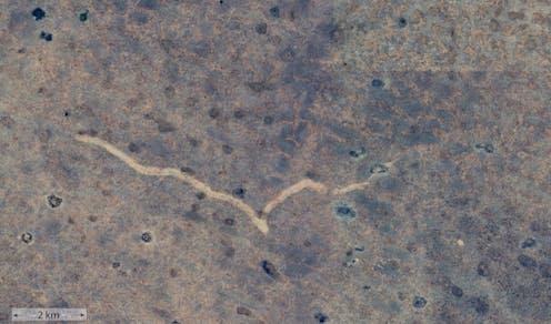
The scar stretches from Western Australia over the border to South Australia. It lies 20 kilometres north of the Trans-Australian Railway and 90 kilometres east-north-east of Forrest, a former railway settlement.
We compared satellite imagery of the site over several years to determine that the tornado occurred between November 16 and 18, 2022. Blue circular patterns appeared alongside the scar, indicating pools of water associated with heavy rain.
My colleagues and I then travelled to the site in May this year to examine and photograph the scar and the neighbouring landscape.
Our results have been published today in the Journal of Southern Hemisphere Earth Systems Science.
What we found
The scar is 11 kilometres long and between 160 and 250 metres wide. It bears striking patterns called “cycloidal marks”, formed by tornado suction vortexes. This suggests the tornado was no ordinary storm but in the strong F2 or F3 category, spinning with destructive winds of more than 200 kilometres an hour.
The tornado probably lasted between seven and 13 minutes. Features of the scar suggest the whirling wind within the tornado was moving in a clockwise direction. We also think the tornado moved from west to east – which is consistent with the direction of a strong cold front in the region at the time.
Local weather observations also recorded intensive cloud cover and rainfall during that period in November 2022.
Unlike tornadoes that hit populated areas, this one did not damage homes or towns. But it left its mark nonetheless, eroding soil and vegetation and reshaping the Earth’s surface.
Remarkably, the scar was still clearly visible 18 months after the event, both in satellite images and on the ground. This is probably because vegetation grows slowly in this dry landscape, so hadn’t yet covered the erosion.
Predict and prepare
This fascinating discovery on the Nullarbor Plain shows how powerful and unpredictable nature can be – sometimes without us knowing.
Only three tornadoes have previously been documented on the Nullarbor Plain. This is likely because the area is remote with few eye-witnesses, and because the events do not damage properties and infrastructure. Interestingly, those three tornadoes occurred in November, just like this one.
Our research provides valuable insights into the tornadoes in this remote and little-studied region. It helps us understand when, and in what conditions, these types of tornadoes occur.
It also emphasises the importance of satellite imagery in identifying and analysing weather phenomena in remote locations, and in helping us predict and prepare for the next big event.
And finally, the results are a stark reminder that extreme weather can strike anywhere, anytime.
Authors: Matej Lipar, Adjunct Research Fellow, School of Earth and Planetary Sciences, Curtin University